ESA has officially published the INTMAP project on its Business Applications platform, a project led by Greensee, and reinforcing the satellite intelligence capabilities behind the GEOCE geofencing platform.
The ESA INTMAP project strengthens GEOCE’s ability to deliver high-precision, satellite-based maritime geospatial intelligence for shipping companies, ports, and intermodal operators operating in complex global supply chains.
View the official ESA project page:
https://business.esa.int/projects/intmap
Strengthening GEOCE’s Geospatial Core
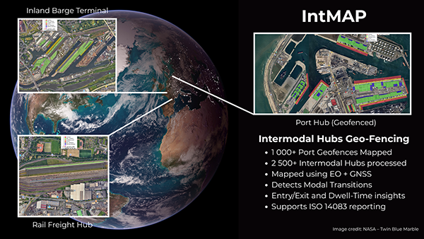
GEOCE is Greensee’s advanced maritime geofencing and hub detection engine. It provides subzone mapping, terminal segmentation, and spatial intelligence across dense port environments.
Through the ESA INTMAP project, GEOCE integrates enhanced satellite positioning and Earth observation data to improve:
- Subzone detection accuracy within complex terminals
- Hub and port call identification precision
- Dwell time measurement reliability
- Multimodal journey reconstruction
- Location validation for emissions allocation
For shipping companies managing thousands of containers across jurisdictions, spatial precision directly improves operational visibility, reporting confidence, and performance optimisation.
Supporting Maritime Decarbonisation and EU ETS Compliance
Maritime decarbonisation is accelerating under EU ETS and FuelEU Maritime regulations. Shipping companies must accurately classify voyages, validate port calls, and report emissions with clarity and consistency.
Precise geofencing strengthens:
- Identification of intra-EU and extra-EU voyage legs
- Port call and berth detection accuracy
- Journey-level CO2 allocation
- Audit-ready emissions reporting
By enhancing GEOCE through the ESA INTMAP framework, Greensee improves the data integrity required for shipping emissions tracking and regulatory compliance.
This enables operational decisions and sustainability reporting to be grounded in high-resolution, verifiable geospatial intelligence.
Integrated Across the Greensee Platform
The enhanced GEOCE platform forms the spatial backbone of Greensee’s modular intelligence stack:
- GEOCE – Satellite-based maritime geofencing and hub detection
- TRACE – Real-time container tracking and journey-level CO2 modelling
- VISTA – Port and terminal performance optimisation dashboards
- RISE – Connected container and reefer intelligence with energy and emissions insights
Satellite precision from INTMAP strengthens GEOCE’s spatial layer, which directly enhances journey analytics in TRACE, terminal optimisation in VISTA, and asset-level monitoring in RISE.
Together, this architecture converts satellite signals into structured operational intelligence for performance, compliance, and maritime decarbonisation.
Advancing Space-Enabled Maritime Intelligence
Publication of the INTMAP project on the European Space Agency Business Applications platform marks an important milestone in Greensee’s growth.
It reinforces our commitment to building custom AI-powered maritime intelligence solutions where satellite-enabled precision is embedded directly into operational workflows.
As regulatory pressure and performance expectations increase across global shipping, data accuracy becomes a competitive advantage.
Explore our modules: GEOCE | TRACE | VISTA | RISE
Connect with us at greensee.ai/contact to discuss how satellite-enabled intelligence can support your operations.